
IntelliGIS ®
| About IntelliGIS | |
| IntelliGIS - Printing | |
| IntelliGIS - Integration | |
![]() download
download
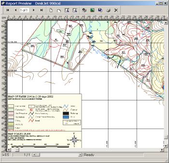
IntelliGIS - Printing
|
IntelliGIS provides an advanced,
yet easy-to-use, interface to generate maps (to scale and in projection)
from any GIS information represented using IntelliGIS. To achieve
the ultimate map composition, the maps can be customized with user-defined
logos, legends, company information and text using the Print Composer.
ISS realizes that map output is an integral part of managing a GIS.
IntelliGIS provides an extensive set of options to ensure that maps
are of an extremely high standard. Printing GIS has never been easier... |
 |